History Highlights 5: Air Age Maps, Nukes in the Sky, and the Tao Te Ching

In Highlights, I share a collection of interesting history things I’ve come across recently. In this edition: an interesting map, an atmospheric nuclear detonation, and Ursula le Guin’s version of the Tao Te Ching.


I was recently gifted The Library of Lost Maps by James Cheshire. One of the maps he uses to introduce the book is this 1945 “Air Age Map of the World.” By the end of WWII, air travel was becoming more accessible, and the people who made maps like this were looking forward to widespread air travel in peace time. The map is centered on London, and uses a map projection that shows straight-line routes to major destinations.

The Air Age Map of the World (1945) by Edward Stanford Ltd. From Wikimedia.

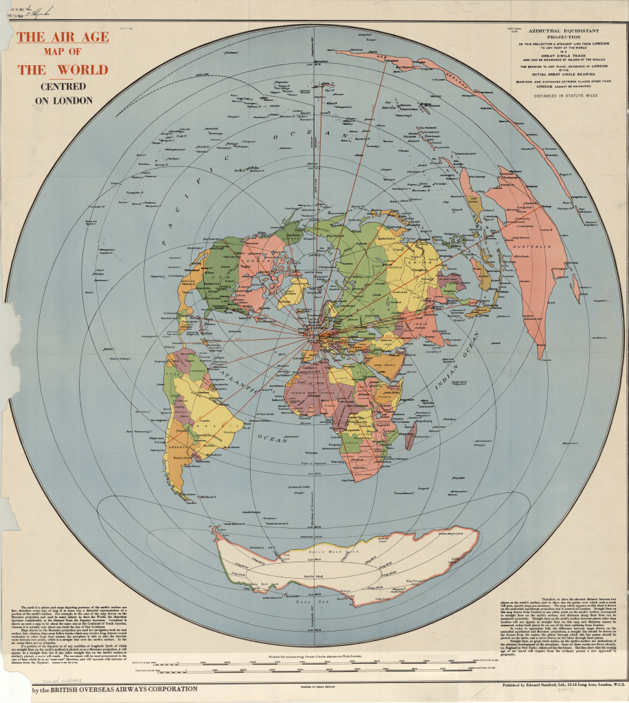
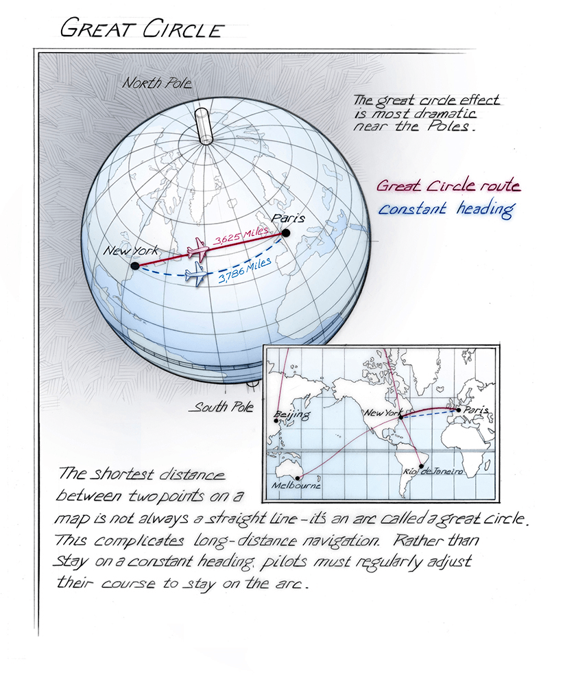
It’s a great example of how modes of travel can literally reshape maps. The nice thing about planes is that you can fly straight from one city to another–but because the Earth is roughly spherical, that direct route appears curved on our usual map projections. Pilots use a technique called great-circle navigation to take the shortest route between two place (see the illustration below). “Air Age” maps often use an azimuthal equidistant projection, which shows the great circle routes as straight lines emanating from the center of the map.

This fantastic illustration by Bruce Morser is a great demonstration of great circle routes. Source: National Air and Space Museum, Smithsonian Institution.

The map reminds me of the Tabula Peutingeriana (TP), which shows the Roman road system. The TP is a medieval map that may have roots in classical sources. It’s shape was partly due to the technology it was produced with: parchment scrolls. But also, its aim wasn’t necessarily to produce an accurate physical description, but to show important sites in the empire and their connections with each other. This could aid the reader in imagining the relevant geography of the region. (More from Michael Rathmann: PDF).

One part of the TP, showing the tip of Italy and Sicily. From Wikimedia. If you’re interested, you should check out the whole image, which is quite large. It’s fun to explore.

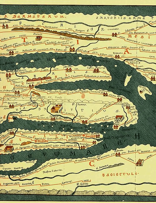
These maps sacrifice geographic fidelity for the sake of displaying the relationship between places. In these cases, that relationship is defined by specific transportation technologies. The classic example of this that many people today are familiar with are subway maps.


In 1962, the United States detonated a thermonuclear warhead in the atmosphere above Hawaii. Part of a project called Starfish Prime, the detonation impacted communications on the ground and the telecommunications satellites in orbit at the time. It provided opportunities for scientists to study the effects (both at the time: PDF, and decades later), reaffirmed the dangers of testing nuclear weapons in the atmosphere, and preceded bans of atmospheric nuclear weapons testing.

A shot of the Starfish Prime test from a plane. From Wikimedia.

Finally, I’ve been reading a collection of poems by Ursula Le Guin. I was delighted to find that the collection includes her own rendition of the Tao Te Ching. She calls it a rendition, rather than a translation, since she wrote through comparing different English translations of the text, looking at differences in translation for specific characters. She used the Paul Carus translation as a “touchstone,” since it included details on each Chinese character used. Le Guin writes:


“If I could focus on which word the translators were interpreting, I could begin to understand why they made the choice they did. I could compare various interpretations and see why they varied so tremendously; could see how much explanation, sometimes how much bias, was included in the translation; could discover for myself that several English meanings might lead me back to the same Chinese word. And, finally, for all my ignorance of the language, I could gain an intuition of the style, the gait and cadence, of the original, necessary to my ear and conscience if I was to try to reproduce it in English.”

Ursula Le Guin, Collected Poems, Page 290

She compiled it over decades, eventually receiving support and guidance from Dr. J.P. Seaton, a professor and translator. Le Guin’s rendition is interesting to me not so much as an authoritative translation, but as a way to access the meaning Le Guin found in the text. That meaning, regardless of accuracy or connection to the original, was enormously influential on who she was as an author and as a human being. In that a way, it’s a bit like the maps at the beginning of this post. Reading it has been a way to ground myself lately. I wanted to end with a couple chapters that hit particularly hard:

30
Not Making War


A Taoist wouldn’t advise a ruler
to use force of arms for conquest;
that tactic backfires.

Where the army marched
grow thorns and thistles.
After the war
come the bad harvests.
Good leaders prosper, that’s all,
not presuming on victory.
They prosper without boasting,
or domineering, or arrogance,
prosper because they can’t help it,
prosper without violence.

Things flourish then perish.
Not the Way.
What’s not the Way
soon ends.

31
Against War


Even the best weapon
is an unhappy tool,
hateful to living things.
So the follower of the Way
stays away from it.

Weapons are unhappy tools,
not chosen by thoughtful people,
to be used only when there is no choice,
and with a calm, still mind,
without enjoyment.
To enjoy using weapons is to enjoy killing people,
and to enjoy killing people
is to lose your share in the common good.

It is right that the murder of many people
be mourned and lamented.
It is right that a victor in war
be received with funeral ceremonies.

History Highlights 3: Mapping the Ocean and the Moon, Living Museums, Ancient Arctic Voyages

Welcome to Inverting Vision, a blog about the history of exploration, science, and technology. From this point forward, I will be publishing posts every Thursday unless fate intervenes. History Highlights will appear occasionally as I work on more substantial posts. Next week I’m hoping to write about the scientific instruments that appear in Herbert Ponting’s photographs of the British Antarctic Expedition. Until next week, here are some highlights from my readings and the wider exploration and science community.

Do we know more about space than the deep sea?

Probably not these days, according to marine scientists Alan Jamieson, Premu Arasu, and Thomas Linley. In a fantastic article in The Conversation, they write that the truth of this notion depends on what comparisons you make. They explain that if you just consider the Moon, it may have been true during a small window in the 1950s and 1960s. In fact this may have been when the impression that we know more about space than the oceans originated. In those decades scientists were mapping the Moon more extensively, especially as NASA prepared for the Apollo landings. The Surveyor and Lunar Orbiter missions played a key role in this process, taking photographs of the lunar surface that were used by scientists and Apollo mission planners.

A photograph of the far side of the Moon from Lunar Orbiter 3. From NASA/LOIRP.

But this same period was very early in the history of fruitful deep sea oceanography. Echo sounding tech had only been in use for a few decades, and scientists were just starting to use echo sounding to map the seafloor (the first truly comprehensive map wasn’t published until Marie Tharp’s map in 1977). The authors of the article argue that since then, more robust exploration of the deep sea has produced a wealth of knowledge that probably surpasses our knowledge of the Moon and especially Mars. Go read their article to learn more.

A painting of Marie Tharp’s map by Heinrich C. Berann. From the Library of Congress.

In my experience, people casually referring to this idea often extend it to saying that we know more about “space” than the ocean. This must be even farther off the mark, even when you just consider objects in our solar system and disregard exoplanets. Europa and Enceladus may contain entire oceans that we know very little about. I’m looking forward to the launch of the Europa Clipper mission in 2024, which will hopefully bring us more information about Europa (although it won’t arrive at Jupiter until 2030).

Alvin and the Recovery of a Broken Arrow

Woods Hole tweets about the role DSV Alvin played in the 1966 recovery of a hydrogen bomb (referred to as a “broken arrow”) from the bottom of the Mediterranean.

Missions for the military were relatively common in the early days of deep-submergence vehicles, and especially for Alvin. The scientists were sometimes able to tack on scientific objectives to these missions, or military missions became a way to test or fund the development of vehicles and scientific projects. The relationship between the military and deep sea exploration will probably be a topic for a future blog post.

The Curious Life of the Vema

The Vema was an oceanographic research vessel that played a crucial role in the early mapping of the ocean floor and exploration of the Mid-Atlantic Ridge in the 1950s. Marie Tharp and her research partners used data from the Vema to create the seafloor map mentioned earlier. But that was only one small chapter in the life of the Vema. The sailing vessel was built in the 1920s for a wealthy American financier who used it as a yacht and hosted actors and celebrities. He sold the yacht to a Norwegian buyer who gave it the name Vema. Then the US military acquired the Vema in WWII and used for training. After the war the military discarded it, and eventually it was recovered and sold it to Columbia University, where it was used as a research vessel until the 1980s. Since then, it has been a chartered yacht for vacations in the Caribbean. Last year the yacht company announced they had new plans for the ship formerly known as Vema. They haven’t revealed what the new plans are.

The Vema being used as a training vessel in World War II. From Wikimedia.

Whales as Living Museums

Bathsheba Demuth writes about the role of whales in the history of Beringia in her book Floating Coast. She describes how bowhead whales were hunted by various groups throughout the history of the region. Sometimes the whales escaped these hunts with harpoons still buried in their bodies. Because bowhead whales can live for over 200 years, they sometimes collected a decent number of the tools used against them. Demuth describes a particular whale that carried “a museum of old weapons in his flesh.” These weapons ranged from ivory harpoons to explosive lance tips.

Ancient Voyage to the Arctic

It’s possible that in the 4th century BCE a Greek explorer named Pytheas ventured as far as the Arctic north of Europe, but later classical writers seriously doubted his claims. We know about him from later writers like Strabo and Polybius. In the Histories, Polybius recounts with skepticism Pytheas’ claim that in the far north “there [was] neither unmixed land or sea or air, but a kind of compound of all three (like the jelly-fish or Pulmo Marinus [sea lung]), in which earth and sea and everything else are held in suspense, and which forms a kind of connecting link to the whole, through which one can neither walk nor sail.”(Plb. 34.5) Voyages this far were rare for the Greeks, and Polybius was in part doubtful about how far Pytheas claimed to have sailed.

For more History Highlights from past weeks, click here. Follow the Inverting Vision Twitter account for updates on posts and other history of exploration and science content. Subscribe to get update in your inbox:

I strive to make my writing as accurate as possible. If you have a correction or a suggestion for a post, please leave a comment or email me at invertingvision@gmail.com. If you liked this post, please share it!